| Lane Home Page | Search Lane |
| Website Accessibility |
Campus Long Range Planning : Chapter Five : Present Conditions
Series : Conceptual Vision Home : Table of Contents, Executive Summary : Chapter One : Chapter Two : Chapter Three : Chapter Four : Chapter Five : Chapter Six :
This Page : The Study Area : Site and History : Zoning and Land Use : Participatory Planning In Action : Administrative Roundtable : Visioning Workshop : Problem Seeking : S.W.O.T. Analysis : Strengths : Weaknessess : Opportunities : Threats : Blights and Rights :
: Consolidated Blights : Blights-Entry : Blights-Gathering Spaces : Blights-Way-Finding : Blights-Location : Blights-Accessibility : Blights-Disconnected Parcels : Blights-Transportation : Blights-Architecture : Blights-Views : Blights-Layout :
: Consolidated Rights : Rights-View Shed : Rights-Location : Rights-Compact Campus : Rights-Sturdy Construction : Rights-Space to Grow : Rights-Transportation : Rights-Art : Rights-Values : Rights-Great Community : Rights-Unique Facilities :
Research for the Future : Physical and Human Environment : Future Needs and Uses : Physical and Human Environment : What makes a great place? : What are the physical elements of a great college campus : What makes a great building? : What makes a great learning space? : Future Needs and Use : What is your idea of LCC’s (educational) vision for the next 20 years? : What current programs could use new facilities? : What should be done with LCC’s surrounding landholdings? : Vision, Goals, Principles : Guiding Goals : Design Principles :
: Equitable Accessibility Goals: Page 1 : Page 2 :
: Sustainable Buildings & Landscape Practice Goals : Page 1 : Page 2 : Page 3 : Page 4 : Page 5 : Page 6 :
: Appropriate Infrastructure Goals : Complete Community Goals : Feasability Goals :
Chapter four introduced the theory and methods of participatory
planning as “a transparent, democratic process
that uses consensus building through the collaboration
of ideals, values, objectives and input from all participants
(Comerio 1984).” Additionally, this model opposes the
traditional model, top-down approach to planning, which is
customarily client-serving rather than vision-making (Francis
1999). This method is intended to enable and empower
the participants; identify problems and opportunities; and
facilitates the vision, goals and principles developed during
the workshops process (Hamdi and Goethert 1997;
Sanoff 2000). As identified in chapter one, the economic
crisis, budget cuts and spiking enrollment have conspired to
create a perfect storm for higher education is one of many
reasons LCC has pursued a line of research that will help
develop an alternative development strategy for the 21st
century community college; one that will help foster economic,
social and environmental accessibility.
This chapter presents this initiative under the framework of participatory planning as discussed in chapter four. It also presents the sites’ characteristics and history, the participatory planning experience, and then reveals the opportunities and constraints identified from the two public workshops.
This project focuses on land that is located at the edge of the Eugene and Springfield metropolitan areas that runs perpendicular to Interstate Highway 5 (I-5) although partitioned by two adjacent properties. The site selection process in LCC’s Long Range Plan (1966-76) is similar to those discussed at a 1967
Council of Educational Facility
Planners conference identifying five general site location
factors: geography, general and school population, transportation
and communication, and economy (Parker and Smith
1968). After a review of these factors, the LCC Board of
Land Acquisitions chose the existing site out of nine potential
locations, which involved a gift of one hundred acres
and the purchase of forty-eight additional acres (LCC Long
Range Plan 1966). This locational typology would become
pervasive for community colleges throughout America and
confirms that development at the edge, primarily designed
to support automobile access and, to a lesser extent, public
transit; focused towards a single industry, developed at a low floor-area-ratio, and oriented around large parking lots,
is characteristic of contemporary shopping malls, hospitals,
religious organizations and community colleges in the
United States (American Association of Community Colleges
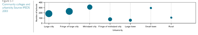
2008). Furthermore, roughly 24% of community colleges
are defined as being on the fringe of both large and midsized
cities (see figure 5.1) capturing approximately 32% of
total enrollment (see figure 5.2).

![]()
An overarching goal for LCC was, and still is, to provide “access” to every citizen of Lane County (LCC Long Range Plan 1966). “Education for all” is a democratic notion that manifests itself both literally and figuratively in the selection of a site that is geographically accessible to all county residents (LCC Long Range Plan 1966).
In fact, the location of many community colleges highlights a suburban focus. As Andrew and Fonseca note, many community colleges are located near high volume roadways at the fringe of metropolitan American communities (Andrews and Fonseca 1998). Their campuses have poor connectivity to the metropolitan fabric and they typically do not integrate industries that support their mission on their land. These fringe developments enforce inefficient land use patterns, contribute to time lost due to congestion, and restrict transportation options.
In addition to Lane Community College’s main campus being an ideal study area because it is a representative model of single industry peripheral metropolitan development, it also has a user group of over 40,000 people - full and part time faculty, staff and students - that travel to and use its campus annually.
Site and History. Lane Community College (LCC)
website states they serve a 4,600 square miles area, with
a county population of 346,500, ranging from the Cascade
Mountains to the Pacific Ocean. LCC is located outside
of the Eugene and Springfield Urban Growth Boundaries
(UGB), but within the Metro Plan Boundary (MPB) in
the south hills of Eugene, Oregon (see figure 5.3). Eugene
(population 154,000) and adjoining Springfield (population
57,000) make up the second largest population center in
the state (US Census, American Fact Finder 2006-2008).
In 1964, local citizens voted to establish the college. The
Eugene-based architecture firm, Balzhiser, Seder & Rhodes,
developed the Comprehensive Campus Plan for Lane
Community College in 1965-66 with two main principles:
- An egalitarian view where the vocational/ technical and college transfer programs are integrated to create a collective campus community focused around a center building, literally set in the middle of campus, to serve all students; and
- The flexibility of all spaces to be built with non-structural walls to enable the remodeling of spaces, changing with the college’s enrollment and educational needs.
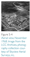
The main campus opened in 1968 and currently has branch
facilities in downtown Eugene, a Flight Tchnology Center
at the Mahon Airport
(Eugene) a Business
Development Center
in the Wildish Building (Eugene) and two additional
centers in Cottage
Grove and Florence. In
1995 a bond Measure
passed and several new
buildings were added
to the campus. Most
recently, in 2009, in conjunction
with a second
bond measure, state and
private funding, some
renovations and two new buildings are being funded. Besides
these recent projects the main campus has had very
little change since its initial development (see figure 5-4).
Zoning and Land Use. The UGB is the primary growth
management technique for controlling urbanization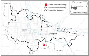 in
Oregon communities that controls the potential for urban
sprawl and scattered development (Porter 2008). The UGB
separates urban and urbanizable lands from rural lands. The
MPB bounds the area that includes Springfield, Eugene, and
unincorporated urban, urbanizable, rural, and agricultural
lands and is defined in the Metro Plan (2004). The Metro
Plan lays out the planning policies and land use allocations
in
Oregon communities that controls the potential for urban
sprawl and scattered development (Porter 2008). The UGB
separates urban and urbanizable lands from rural lands. The
MPB bounds the area that includes Springfield, Eugene, and
unincorporated urban, urbanizable, rural, and agricultural
lands and is defined in the Metro Plan (2004). The Metro
Plan lays out the planning policies and land use allocations
allowable within its boundary. It serves as the basis for the “coordinated development of programs concerning the
use and conservation
of physical resources,
furtherance of assets,
and development or
redevelopment of the
metropolitan area. The
Metro Plan is intended
to designate a sufficient
amount of urbanizable
land to accommodate
the need for further
urban expansion…
of metropolitan Lane
County and the cities of
Eugene and Springfield”
(Metro Plan 2004).
LCC is made up of roughly 330 acres divided into five
parcels (see figure 5-5 and 5-6). The entirety of LCC’s land
holdings are roughly bound by I-5 and Eldon Schafer Drive
to the east, 30th Avenue to the north, Gonyea Road to the
west, and undeveloped forest land to the south. A description
of each parcel and its Metro Plan designated land use follow.
The first two groupings are designated as ‘Government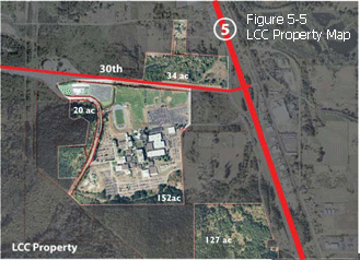
and Education’ land in the Metro Plan.
- The main parcel is 153 acres and includes: 35
acres of the core campus surrounded by 32
acres of parking, 7 acres of wastewater-treatment
lagoons, and 83 acres of road and open
space. - Two parcels, 10 acres each, lie to the west and
south of Gonyea Road and are predominantly a
mixed Douglas-Fir forest and wetlands.
The third grouping is designated as ‘agriculture’. - 30 acres of forested wetlands lies to the north
of 30th Avenue and west of McVay Highway.
The eastern portion of this area is fill from
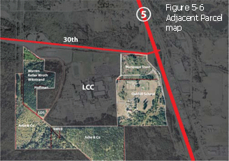 illegal dumping that has long been halted. This
parcel has a handle which protrudes north
towards Bloomberg Road.
illegal dumping that has long been halted. This
parcel has a handle which protrudes north
towards Bloomberg Road.
The last group is designated ‘Forest Land’.
- 127 acres of mixed Douglas-Fir forest lies
to the southeast. It is disconnected from
the main campus core and there is rumor
that this site was used as a Native American
winter camp site.
PARTICIPATORY PLANNING IN ACTION
Participation is important because people have the right
to participate in decision-making that directly affects their
environment. “This means direct public involvement in
decision-making processes whereby people share in social
decisions that determine the quality and directions of their
lives (Sanoff 2000).” Taking into account these ideas, Lane
Community College choose to work with the Urban Design
Lab (UDL) as a partner, who is committed to promoting
participation in planning through the participatory planning
method and strategy outlined in chapter four. Some
main goals of the UDL were to organize ongoing meetings
for consultation about the present situation of LCC (this
chapter), administer and analyze an online user survey (appendices
III-V), prepare a vision statement, guiding principles
and measureable goals that took place during the two
workshops (this chapter); create and evaluate alternative
design approaches and submit an agreed upon preferred
alternative that is implementable (chapter six).
Administrative Roundtable. In early October, to lead off the planning process, the Urban Design Lab sat and listened to the concerns and hopes of the LCC administration. The discussion that ensued served as the beginning framework for the two public workshops.
Mary Spilde, the President of LCC Public, pointed out that “funding on the national level can be challenging… that Oregon was a poster child of disinvestment” and now that the country is in a recession, noted that funding is even more challenging. She also acknowledged “there will never be enough funding, even with the twelve billion dollars investment President Obama’s administration is making available.”
President Spilde remarked that out of this process she hoped “to leave a legacy…to the greater community”
Sonya Christian, the VP of Academic & Student Affairs, felt that LCC’s commitment to the long range visioning process mirrored its commitment to the future of the college. She also pointed out that the school needed to continue its commitment towards sustainability, specifically referencing: (1) how environmental sustainability was already inline with their key values; (2) that their continued support of social sustainability (social justice) needed to be imbedded in to the physical plan; and (3) the need to ensure their own future through fiscal sustainability.
The chief financial officer, Greg Morgan, was very insistent that “all residents of Lane County were shareholder of LCC’s assets” and “that the public should be included in the process.” President Spilde agreed and was interested in finding out “what the
stakeholders thought were LCC’s strengths and how best to capitalize on them…taking our destiny into our own hands.”Other LCC administrators’ hopes included: “wanting to use our land as an asset…the desire for the long range visioning document to coincide with the educational mission to help ensure fiscal and educational future success…better wayfinding… taking advantage of the spectacular site…the need for curb appeal in a new design was important…” Furthermore, the administration brought to our attention three additional concerns that needed to be considered: (1) the current LCC design guidelines have incorporated the results of a student survey capturing preferences and opinions on environmental quality at LCC; (2) that LCC sits outside the urban growth boundary and that there is potential for an expansion of either the Eugene or Springfield urban growth boundaries; (3) LCC has interest in pursuing public and private partnerships that could create opportunities to better serve the college.
Visioning Workshop. The workshops aim was to identify,
prioritize, document and analyze the local environmental,
social and economic challenges, and opportunities through
a collaborative discussion of shared knowledge, in which
people came to learn about potential impacts, problems
and opportunities, and possible ways of valuing and addressing
them. The information collected during the two
workshops was used to compile a list of goals and broad
objectives to formulate a vision statement that directs the
ongoing development vision design process.
Both workshops were held at Lane Community College’s Center for Meeting and Learning, therefore adhering to the fundamental principles of holding the collaborative group workshops on-site. The first workshop was held on Monday, October 19th and the second, on Saturday, October 24th, 2009. Both workshops were held from 9am to 2pm. Twenty-five LCC faculty, staff and students, two design professionals, and one adjacent landowner representative (EWEB) participated in the first workshop; and nine LCC faculty, staff or students, three neighbors, two local professionals, and one adjacent landowner representative (Arlie & Co.) participated in the second workshop.
The participants were asked to sit at round tables of six to
eight people and to the best of their ability, sit with people
with whom they had no affiliation. Participants were asked
to actively participate in the brainstorming exercise and
told that no one should criticize any ideas. Guidance was
provided at each table by University of Oregon Architecture
students (UDL interns) and under the supervision of
the faculty advisor and UDL founder, Mark Gillem. The UDL
project manager, Barry Gordon led the workshops. Twentyseven
design team members took part in the visioning
process acting as presenters, facilitators and scribes. Input
from the design team was not included in the data analysis.
In order to keep their data separate the letters “UO”
were placed next to design team member’s input. After the
introduction of the day’s goals for the workshop, but prior
to the beginning of the participatory process, the Urban
Design Lab presented its findings from precedent studies
of regional community colleges. Hamdi calls the process of precedent studies as “measuring” and describes it as “[l]
ooking, listening, and talking” (Hamdi and Goethert 1997).
Although, Hamdi described this method as more quantitative
than qualitative, our experiences during the case studies
were quite the opposite. We held both formal and informal
interviews, toured the campuses and diagrammed. These
studies can be found in chapter three of this document.
Problem Seeking: The visioning workshops were structured
to maximize collaborative participation through a
series of four exercises. The discussion started with identifying,
prioritizing, documenting and analyzing opinions and
preferences in the first two exercises by
using the Crawford Slip technique. Dr. C.C.
Crawford, Professor of Education at the University
of Southern California, invented the
Crawford Slip technique in the 1920’s. This
method allows for large groups of people to
brainstorm a lot of ideas in a short period of
time by writing and then collating the input
or ideas on slips of paper (Andersen 2007).
Using the Crawford Slip data gathering technique,
the participants brainstormed ideas
for two minutes per question - one idea per piece of paper - with no limit in the quantity
of ideas, except for the time. The data was
gathered quickly and collected in separate
envelopes. After all the questions had been
asked, each team was assigned an envelop
to sort and discuss the ideas, order them
thematically, and prioritize them by syntax quantity. The
themed data was then developed into concept tree diagrams – this is a graphic representation of the ideas - then
presented the diagrams to the entire group. (Major themes
are presented in italics.)
S.W.O.T. Analysis. The first exercise asked questions dealing with the strengths, weaknesses, opportunities and threats at LCC. What materialized out of this exercise was a hierarchy of beliefs and preferences that have helped create the collection of opportunities and issues for the project.
Six main STRENGTHS were identified in this section (see figure 5-7). Recognition of the commitment and caring leadership of the Staff and Faculty are intimately connected to forward thinking, and an open community that continues to support LCC’s continuous ability to adapt and add variety and quality classes to its Educational Mission. In addition, LCC has a large Portfolio of Land that presents the chance to utilize the Surrounding Landscape to its advantage. The qualities of accessibility and circulation are linked to the Proximity of surroundings cities (Eugene and Springfield), the natural setting, the campus core and nearness of two major roadways. The last theme – Buildings – deals with cohesion of style, durability, closeness to each other, and the indiscernible center of campus.
Figure 5-7 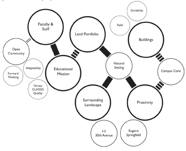
A majority of the WEAKNESSESS illustrated the Locational
Disadvantage and the issues of campus parking (see figure
5-8). The juxtaposition of the sea of parking to surrounding
natural areas encroaches on the Accessibility and Imageability
of the campus. Additionally, the qualities of wayfinding,
architectural aesthetic, and lack of after-hours activities create
a bland and Uninteresting Environment.
Figure 5-8 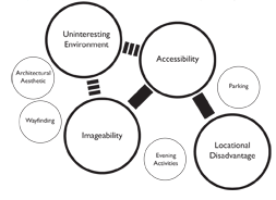
All the OPPORTUNITIES recorded connect the universal desire by the participants for Growth (see figure 5-9). LCC’s Land Holdings can be developed as an incubator to create jobs, increase revenue, and reaffirm its commitment to Sustainability practices by linking and growing existing and new Academic Programs to this mission. Many of the supporting intentions are listed here: childcare, senior living and learning, arts, housing, hospitality, environmental stewardship, green leadership programs and buildings, open space and rainwater management, enterprising partnerships, a campus village, outreach support to community functions, students, and the college’s attractiveness to international and out-of-state students.
Figure 5-9 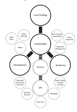
The list of THREATS was long and comprehensive (see
figure 5-10). The lack of a Long Term Planning Vision connects
all of the major themes of this category and is closely
linked to the ills of Unguided Development and the concern
of encroaching Sprawl. Additionally, being located outside
the urban growth boundary is another planning hurdle and
includes the lack of Urban Services, such as sewer and water.
This Locational Disadvantage highlights many public safety
concerns like limited campus security, emergency response
time, and isolation and lighting limitations. The poor and
intimidating Architectural Style of the buildings was also
noted as costly to maintain, limited in terms of functionality
and credited for creating unhealthy environments. The Lack
of Funding and competition in these poor economic times
is a major concern when budgets are getting cut, the cost
of transportation is rising, an overflow of students that can
not be accommodated, a lessening of community support
and a lack of federal loans to students means lower affordability.
The Community is listed as a threat that heightens a
perceived lack of political support, mindless naysayers, and
competition between other regional colleges and universities.
Climate change, the surrounding habitat and fear of natural disasters round out the threats in the Environmental
theme.
Figure 5-10 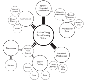
Blights and Rights. In the second exercise, the participants
were asked to brainstorm as many blights and rights as
possible in a five minute period. Blights are any physical
or environmental attributes that are an issue and need to
either be removed or significantly addressed; and Rights are
any physical or environmental attributes that should continue
or enhanced. At each table the workshop participants grouped the data into a ‘David Letterman style’ top-ten list
of blights and rights. Each group was given two minutes to
present their top-ten list to the entire group. The data was
then compiled into corresponding topics and given a more
detailed theme heading. The consolidated list of blights and
rights below is not in a hierarchical order. General comments
from workshop participants are either in quotations
or are preempted by a statement like “meeting participants
felt…” The comments that follow “◊” symbol and that are in
italics are prescriptions from the Urban Design Lab members.
The hope is that the long range vision will correct the
blights and not violate the rights.
Entry. There is no clear definition or hierarchy to the two entries to the campus. Many of the meeting participants felt that “there is little to no designation that you have arrived at LCC…the boulevard along the western edge of campus comes to an abrupt stop when entering the campus… while on 30th Avenue the view into campus is too industrial and unwelcoming.” ◊ A solution is required that creates a deliberate hierarchy of gateways that shows Lane Community College’s character as a place of higher education and its place in the community.
Gathering Spaces. “LCC was designed as a commuter college and there are few if any services that keep people on campus unless they have to be.” Although there are many gathering spaces on campus, a common complaint was that “there are no quality spaces”. ◊ The design team witnessed many people (mostly smoking) using outdoor spaces and this made the environment unpleasant. Locating businesses, cafes, services and improved gathering spaces on or near campus would give faculty, staff and students the option to run errands, study between classes, grab a bite to eat or gather with classmates/friends, and create the lively campus environment that is desired.
Way-finding. Meeting participants commented that the massive size of the architecture, the building names [actually numbers], the lack of a clear central axis and the complex directional kiosk are all factors that led to way-finding issues. ◊ The lack of easily understood directions or cues leads to doubt, confusion and gives rise to a loss of time that could be spent in class or studying. A solution is required that creates clear visual links between buildings, architectural diversity, building uniqueness and necessary signage. In addition, the use of a central clock along converging axis could allow for spatial and time awareness.
Location. Workshop participants commented “the site feels isolated in distance and in safety, sitting alone, outside of the urban growth boundary.” ◊ The future plans should investigate the possibility of ODOT upgrading the I-5 interchange; adding support or incubator services; and developing at a higher density to create the perceived safety needed to foster a safe, lively environment. Hence, bringing the community to the community college.
Accessibility. Meeting participants commented that topography
at LCC makes circulation confusing, especially for people with disabilities. ◊ Connections to surrounding recreation,
bikeways and nearby cities need to be kept in mind. The
future vision of the campus should help create more equitable
parking solutions and be mindful of accessible circulation systems
for pedestrians, bicycles and maintenance vehicles.
Disconnected Parcels. The original plan for LCC states a tight
core of buildings that would create the density needed
to foster community. Many workshop participants were
unaware that LCC owned so much unutilized land. ◊ The
discontinuous parcels should be looked at to connect the community
and the campus. Efforts need to look at design and
political solutions necessary to generate synergy within and
amongst the campus and its surroundings. A solution is required
that may use transfer of development rights, land swaps
or proven design implementations that incorporate connections
to adjacent and disconnected parcels.
Transportation. Workshop participants all commented on the morning commute and the back up that occurs due to the low capacity at the I-5 interchange. Others complained about insufficient bicycle access and facilities, and LTD bus scheduling. ◊ Any plans should include ODOT’s responsibility to upgrade the I-5 interchange and the addition by Lane County of several lights along 30th Avenue. The lights could facilitate new, prominent entry gateways into campus.
Architecture. Meeting participants remarked that the lack of human scale and architectural aesthetic created disconnectedness and sensitivity issues. Other comments collected speak about “sick buildings that lack natural light and have seemingly no soul.” ◊ Research has shown that natural light promotes productivity and creativity. New buildings should be designed to maximize daylight and fit with the region Pacific Northwest aesthetic. Existing buildings should be upgraded to take advantage of sustainable technology and modified to integrate more holistically with its surroundings. In addition, existing buildings should be retrofit to take topographic change, accessibility and human scale into consideration.
Views. Many of the workshop participants commented that
a large portion of the campus does not take into consideration
the “outstanding views of the valley.” Additionally, one
of the highest elevation and “best viewing areas on campus
is dedicated to parking.” ◊ Common knowledge says that this
is high value land; using this space for parking is not using the
land at its best and highest value use. Creating view sheds and
focusing people-oriented activities like recreation and housing,
will allow people to take priority over parking and to enjoy the
natural beauty and setting of the LCC basin.
Layout. Workshop participants comment that the core “campus is densely packed around the ‘Center’ building and almost completely surrounded by parking…and lacks a true focal point.” ◊ The absence of a true center, varying levels of circulation and weak wayfinding makes the visual hierarchy of spaces difficult to traverse. The future vision for the campus should cultivate a building, circulation and open space hierarchy that include gathering spaces and multi-use areas that connect academic, administrative and recreational buildings with multiuse path systems linking the existing with the new.
View Shed. Many of the workshop participants commented on the views to the east, to Mount Pisgah; and open farmland as “beautiful” and “iconically Oregon”. ◊ Although the original design of the campus does not take advantage of this natural view shed, it is not too late. Any future development should take into consideration view corridors and consider building siting. Planning for future development will help ensure optimal view corridors for future generations.
Location. Participants thought the proximity and connection to “surrounding natural and recreation networks…wetlands and forests” make LCC a unique location. ◊ The immediate access to outdoor recreation and educational sites is a quality that is not found at many colleges and should be used to LCC’s advantage. In addition, the site could allow for living or outdoor classrooms using earthworks, wetlands and the oak forest.
Compact Campus. Workshop participants liked the “tight clustering of buildings” that allow for “ease of walking” on campus. ◊ The ‘10-minute walk’ is well documented to be the time frame that most people would consider walking to get to a specific location. Any future plans at LCC must take into consideration the distance/compactness between districts. Furthermore, designing pleasant, appealing, safe and direct street, pathway and building connections will make the walk more pleasant.
Sturdy Construction. Many of the participants stated that the “architectural style of the buildings is a distinctive quality” at LCC. ◊ The stark juxtaposition of buildings to their surroundings highlight the delicacy of the natural environment while displaying great strength in its solid fabrication. While the buildings may stand for a hundred years, the infrastructure of the building will need to be upgraded. In addition, the renovation of restrictive buildings and the application of new facades may be necessary to create a more welcoming environment. New development should take into consideration material use and technology, while being creative and innovative.
Space to Grow. Workshop participants commented that room to grow is not really an issue, but it was the “where and how that needs to be planned for.” ◊ Without a vision for growth, development is doomed to failure. LCC has over 330 acres of land, of which 295 are either parking or open space. Buildings could be phased so as to not impede existing usage or operation. New districts could finance the next phase of growth. Careful planning, direction, political, and financial out of- the-box thinking will be needed to allow for a new model of community college to be developed on LCC property.
Transportation. Participants noted they are “lucky to have cutting edge public transportation options” such as the LTD’s bus rapid transit line (Emx), and dedicated bicycle lanes. ◊ Proximity to I-5, partnership with LTD, and massive amounts of free public parking allow LCC to be a heavily used facility. In order to accommodate growth and density LCC’s transportation assets must grow along with it. The I-5 interchange is already at capacity and could be upgraded to allow for a better level of service. LTD could create a dedicated southern BRT loop between Eugene and Springfield Stations at LCC; parking needs can be accommodated with on-street and center block parking in new districts. Underground parking and parking structures could be added as the need to accommodate more people arise.
Art. “The art is great here”…is a comment many participants
made at the workshop. ◊ Art should be integrated into
any new development on campus. This includes in landscape
ecology and sustainable innovation. Revolving art installations
and “green” beautification projects were also emphasized during
the visioning session.
Values. Many of the participants remarked that all “future planning should reflect LCC’s core values”: Learning, Diversity, Collaboration and Partnership, Innovation, Integrity, Accessibility and Sustainability. ◊ Planners should look to minimize stormwater runoff, sprawl and greenfield development, while maximizing compact and transit-oriented design. In addition, planners should consider sustainability in environmental, social, and economic concerns by containing stormwater runoff in parking gardens, in green space or on green roofs; creating universal access and use of space; and through pioneering partnerships while integrating core curricular programs.
Great Community. Participants made it a point to acknowledge the cooperation and coordination amongst all levels of LCC staff, faculty and students. Additional comments included “how amazing leadership, collaboration and participation” throughout the planning process was. The leadership was said to be “proactive, forward thinking and willing to invest in the future of LCC.” ◊ The enthusiasm and willingness of the LCC community is its greatest asset.
Unique Facilities. Many workshop participants shared the
opinion that “future planning at LCC can integrate with
existing facilities and educational programs” to further the
educational mission of the school. ◊ Future development
should take into consideration the addition of commercial and
retail business, including the linking of incubator businesses
with existing and future education programs, internships and
employment opportunities. These unique programs can become
the cornerstone of future development, contributing to the
stability and durability of Lane Community College and future development opportunities.
The outcomes from the workshop process are separated into current and future conditions. The current conditions, reported on in the first half of this chapter gathered collective knowledge – opinions and perceptions – from LCC faculty, staff, and students along with input from community member and area landowners and professionals. The second area of focus, future conditions; was centered on creating a guiding vision statement, establishing broad objectives and measurable goals based on the same principles of collaboration and consensus building outlined in chapter four.
The work effort thus far has been focused on learning from the past, through the comparative mapping methodology in chapter three; learning from the present, by gathering the users’ experiential knowledge of the sites in the first half of this chapter, and by developing the patterns, preferences opinions, and needs from the preference assessment survey that can be found in appendix III. The first step in the planning process is to establish the issues through problem seeking. The second is to determine a catalogue of design goals and objectives (Hamdi and Goethert 1997) to create a user-informed vision statement. Peña defines a problem statement as “a description of the crucial conditions [problems] and design premises [goals and principles] that become the starting point for schematic design (Peña 2001, 134).”
To help create the vision, the Urban Design Lab focused on
facilitating two more exercises in the latter half of the planning
and design workshops. This part of the workshop was
focused on collecting the community’s needs and preferences.
The exercises centered around two sets of questions.
The first set of questions asked about what makes great
physical and human environments, and the second set
surveyed the future needs and possible uses of the LCC
property. This set of exercises used the same procedures as
the first two exercises described in this chapter. All participants
would answer the questions individually, the answers
would be collected; each team then sorted and discussed
the ideas, and ordered and prioritized them. Each group
then shared their responses to all the participants. The ollowing
two sets of questions were asked to the group.
Physical and Human Environment
1. What makes a great place?
2. What are the physical elements of a great college campus?
3. What makes a great building?
4. What makes a great learning space?
1. What is your idea of LCC’s (educational) vision for the next 20 years?
2. What current programs could use new facilities?
3. What should be done with LCC’s surrounding landholdings?
Physical and Human Environment (Themes are presented in italics.)
1. What makes a great place? The creation of a great place combines building aesthetics, varied spaces, modern technology and the formation of identifiable districts. All have their role in creating a cohesive design & vision identified through a formal planning process. Integrating multiple transit options into the accessibility of a place can help to alleviate congestion, lost time and pollution. Developing a positive (learning) environment for students through the direction of curricula and learning goals can help with student body diversity, motivation and aid in raising the enrollment of international students. Other ideas investigate entrepreneurial and financial avenues that add to the sense of place including public-private partnerships, innovative revenue streams, support service and an incubator service sector that links to the existing educational mission.
2. What are the physical elements of a great college campus? Connectivity, buildings, outdoor environment, and sociological factors are four main themes that have been identified in this question. Transportation, nature trails, urban fabric, community programs, housing and commercial uses are all linked to connectivity. Natural light, sustainable principles, health and safety, variety and quality of forms, design and materials, and inhabitable edges are connected to the built environment. The use of art, landscaping and seating; making a variety of places accessible and hiding large parking lots all create positive outdoor environments. Another theme identifies the necessary thoughtfulness needed in design work to establish sociologically supportive spaces that inspire, welcome, create comfort, community and identity within the institution.
3. What makes a great building? Building functions that encourage interaction and provide positive healthy environments (psychological) that incorporate security and wellbeing and nurture creativity help to create great buildings. Additionally, natural lighting, views and protected pathways are attributes that help create connections to nature and campus. Ease of access to and around campus through wayfinding, easily identifiable circulation systems, and environmental and energy sustainability are three other themes that were identified in the process.
4. What makes a great learning space? The concept map
for this question has a hierarchy starting at the architectural
level with spaces and connections to wayfinding and accessibility.
The theme of architecture incorporates sustainable
buildings that use energy efficiencies and the use of local
materials that would impart the northwest aesthetic. The
next themes include a welcoming, diverse environment for
both staff and students that are defined, yet flexible, have natural light and can include both in and outdoor spaces.
The qualities linking architecture and space create another
heading: healthy buildings and includes operable windows,
allow quality light, ventilation options, and lead to good views.
Technology is the final theme, highlighting both wireless
access and outlets that are easily accessible and equitably
located around campus.
1. What is your idea of LCC’s (educational) vision for the next 20 years? The theme built environment generated the most data, illustrating some of the desired goals as: incorporating a defined campus center, housing, retail, multi-use buildings and a hotel; public transportation, parking, population growth, and walkability of campus; and habitat, storage, art and community pride. A strong graphic link llustrates the desire that the college become more sustainable by incorporated carbon neutrality and alternative energy solutions into the campus and its buildings; the environment was also noted. Aspirations such as affordability, American Disabilities Act requirements and inclusiveness were all attached to accessibility, which was also linked to the built environment. The next two themes were not connected to the first three. They include educational offerings and educational community. Educational Offerings encompass’ departmental breadth, using campus as a learning lab and the connection to transfer and trade students. The last theme, educational community, links the communities needs and the research mission to the overall twenty-year (educational) vision of LCC.
2. What current programs could use new facilities? The answers from this question illustrate one overwhelming desire for a new facility for the environmental energies program, with two other sizeable desires for a new student center and biology facility. Linked beneath those are hospitality, athletics, and advanced technology. Additionally, the fourth tier lists the departments of aviation, welding and automotive.
3. What should be done with LCC’s surrounding landholdings?
There are four main groups with linking subgroups
for each. The primary themes for this diagram are
connections, preservation, building types and utilities. These
themes are connected to each other. Surrounding roadways,
cities and transportation options and facilities, landmarks,
wayfinding, neighboring communities and the environment all
fall under the connections’ main heading. The environment
is shown to have a strong connection to the preservation
theme, with subgroups connected to outdoor classrooms
and recreation trails with urban farming, an interpretive center and an arboretum linking. Building types links housing with
students, faculty, and community; commercial links with retail and a movie theater; nature links with an interpretive center
with a sport/recreation complex, while taking parking and
classroom needs into consideration. The fourth main theme
considers utility needs that encompass green power generation and moving the existing power-lines and dumpsters out
of view.
The results from the workshops created a vocabulary based on experiential knowledge created by the participants through consensus-building exercises. Throughout the workshop, the work produced was pinned up on the walls and at the conclusion of the workshops, it was evident that the participants were excited see the breadth and scope of information they generated by working collaboratively. The concluding exercise asked participants to develop a conceptual vision using tracing paper, a base map and the “knowledge” hanging on the walls. Each vision was considered when transitioning into the design phase of the process and is presented in chapter six: Common Themes. Out of this mass of participant-created knowledge, the Urban Design Lab was tasked to synthesize and analyze the data to generate the measurable goals, which support project objectives that are rooted in the vision statement.
At the UDL studio, the design team sorted and discussed the data created from the workshops to identify the dominant framework and key themes. The completed results from the ‘physical and human environments’ and ‘future needs and uses’ exercises were combined with data from the ‘rights and blight’ and ‘S.W.O.T. analysis’ to create a series of broad design goals. The participant identified principles helped guide the outcomes of the recognized problems. The UDL grouped the principles in categories called goals. Each goal is a broad statement that incorporates the principles that were identified through discussion from the workshops and represented in the diagrammed concept maps. The vision statement was then developed to provide guidance and motivation for the ensuing design process.
At the UDL studio, the design team sorted and discussed the data created from the workshops to identify the dominant framework and key themes. The completed results from the ‘physical and human environments’ and ‘future needs and uses’ exercises were combined with data from the ‘rights and blight’ and ‘S.W.O.T. analysis’ to create a series of broad design goals. The participant identified principles helped guide the outcomes of the recognized problems. The UDL grouped the principles in categories called goals. Each goal is a broad statement that incorporates the principles that were identified through discussion from the workshops and represented in the diagrammed concept maps. The vision statement was then developed to provide guidance and motivation for the ensuing design process.
To create a campus that has appropriate infrastructure that fosters educational excellence through sustainable building and landscape practices organized around equitable accessibility contributing to a complete community.
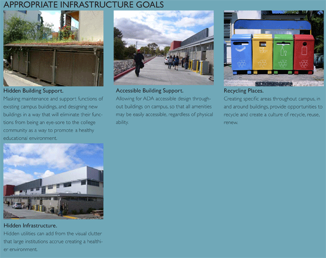
Goal 1: Appropriate Infrastructure. Layout a strategy that incorporates camouflaged support services into the campus core that are efficient and logical.
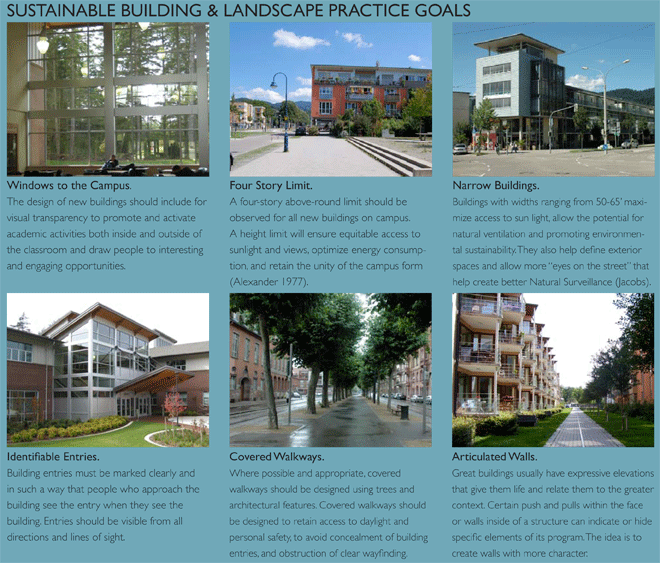
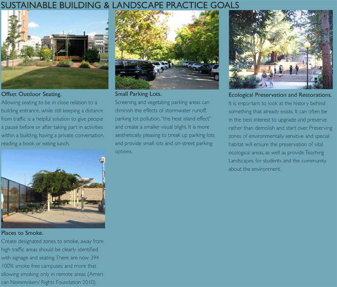
Goal 2: Sustainable Building and Landscape Practices. Produce a vision that maximizes environmental stewardship and green technologies through attractive, well designed, safe, convenient, and comfortable buildings and outdoor spaces.
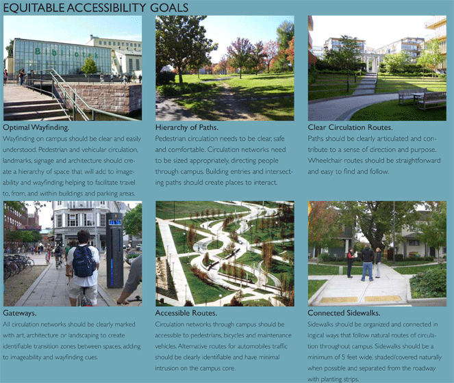
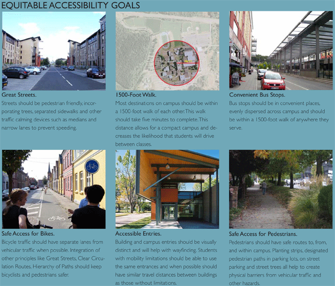
Goal 3: Equitable Accessibility. Provide easily identifiable hierarchy of gateways, roadways and pathways that promote safe, convenient, and comfortable options.
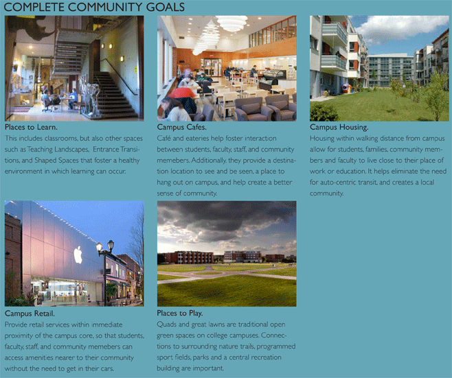
Goal 4: Complete Community. Provides places to learn, live, shop, work and play that help create a well-balanced environment for all Lane County residents.
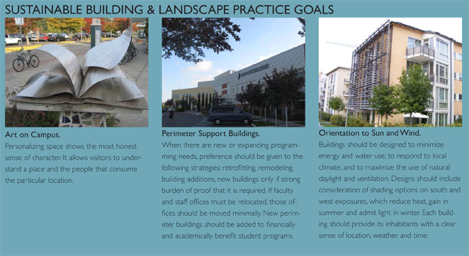
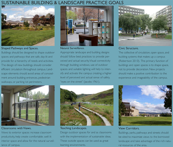
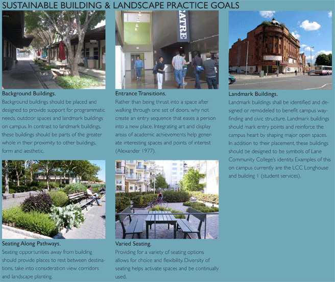
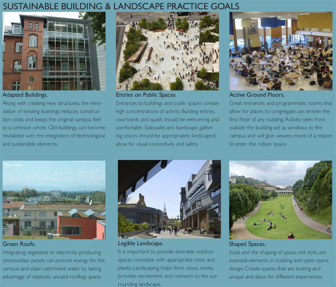
Six months prior to the visioning process, LCC’s College Council adopted a comprehensive list of design guidelines. The Urban Design Lab analyzed these goals and incorporated 100% of them with the results from the visioning workshops’ findings to create an expanded comprehensive list of design goals and principles. The design principles are grouped by goal. Each principle has an accompanying image that expresses its spirit and a written recommendation for the problem identified in the workshops.
Lane Community College - Campus Long Range Planning |
