| Lane Home Page | Search Lane |
| Website Accessibility |
Campus Long Range Planning : Chapter Three : The Campus Paradigm
Series : Conceptual Vision Home : Table of Contents, Executive Summary : Chapter One : Chapter Two : Chapter Three : Chapter Four : Chapter Five : Chapter Six :
This Page : Campus Planning Trends : Defining Form and Charater : Campus Character / Building Typology : Comparative Mapping : Community college selection : Big Bend Community College : Map : Butte College : Map : Central Oregon Community College : Map : Lane Community College : Map : Oregon Coast Community College : Map : College of the Redwoods : Map : Shasta College : Map : Sierra College : Map : College of the Siskiyous : Map : College Comparison Graph : In Conclusion :
“…whenever ideological convictions were
strongly entrenched in the educational curriculum,
architectural continuity was consistently
related to the institution’s past preferences for
architectural style or campus form. Whenever
new educational concepts broke away from the
main stream they were sure to be clothed in
something new. Whenever institutions continued
to hold on to the task of being the leading
edge of thought, their buildings and campuses
were as advanced or as retrogressive as their
time.” (Dober 1964)
In a comparison of college campuses to a city neighborhood or district, the diverse uses included on a campus are coordinated in support of the academic mission. And, as in a city, the whole of the campus is comprised of many pieces. The academic setting of a university or college is more than the sum of individual buildings or open spaces. They are a layering of lessons - passed along from Europe to America - in a long lineage of educational tradition. As noted in chapters one and two, growth of higher education in America is reflected in campus design. Periodic surges of campus construction can be linked to an influx of migration and increase in population (Dober 1964). Dober (1964) notes, “this generalization holds true for the Colonial era and for the cycle of population maturation [baby boomers], that began just after World War II”.
The purpose of this chapter is not to provide an in depth study of the history of campus planning. Rather the objective is to pinpoint, define and diagram the different campus and building form typologies by presenting research on the history of campus development. I will then introduce one of three methods used in this project.
European precedents. The medieval system of master and scholar, found in the guilds, form the basis of universities in Western civilization, setting forth the model for the Colonial college. This model can be traced back to Cambridge and Oxford. The Old World collegiate systems consisted of a grouping of separate colleges - usually endowed by wealthy benefactors - housed under a single university. The model of this university-college system was based on an even older model found at the University of Paris, both in curricula, which was firmly rooted in the dialectical analysis of the Christian doctrine, and the modus operandi. The students attended lectures by appointed teachers, but their housing was their own responsibility. At first, students sought lodging in the homes of the townspeople nearest the university, and then turned to renting entire buildings under the direction of a master. These hostels, or halls; are where the students ate and slept, but otherwise there was little educational framework. This room and board structure was quite common and by the mid-fifteenth century, Oxford had 70 such structures (Turner 1984). Over the next two centuries, the collection of buildings located at eachinstitution standardized, consisting of a chapel, a hall (for dining, lectures and other assemblies), scholars’ and masters’ chambers and accommodations for the head of the college, collectively forming the college. Their composition made up an enclosed quadrangle. This landscape element, shaped by the form of the buildings, created a living and learning environment that became “…the heart of the Oxford and Cambridge pedagogy” (Turner 1984; Thelin 2004).
In America: The early years. Nine colleges were chartered
between 1636 and 1780, all with their common
heritage from the Old World. The founders of the English
Colonies knew the importance of education and had a
desire to preserve the Old World intellectual and cultural
traditions in the new. Additionally important to the founders
was the feeling of permanence of the institution and
the connection to the old ways in the New World. In the
search for educational stability, colonists donated their
homes and privately held libraries for the greater good of a
growing population. Meanwhile, the English Crown intentionally
held back funding for public spaces, parks, public
works, cathedrals and public architecture, thinking there
was no reason to invest in the vast wilderness. This included
the architectural structures for higher education. The lack
of funds available at this time was evident in the layout and
architectural simplicity found at Harvard College (Dober
1964). Yet, this changed very quickly with the construction
of a new building at Harvard, known as Old College (1638),
the largest in New England. Some forty years later, Old
College was replaced by the New College building (1674)
with a structure that was now the largest in the Colonies
(see figure 3-1). The importance of education was clearly
stated through this architectural anchoring (Dober 1964;
Turner 1984; Riera Ojeda 1997; Thelin 2004). In 1753,
Princeton University built Nassau Hall, then, the largest
building in North America (see figure 3-2). If the importance
of education was doubted at this point; in any way, it
was surely solidified with the construction of this building.
A new nation. If the first phase of establishing the
college is rooted in the size and form of buildings, then
the second phase is rooted in the rapid expansion of the
college. This is quite apparent post-Revolutionary War. In
the first three-quarters of the1800s, 281 colleges werefounded, of which 40 then ceased to operate (Thelin
2004). As demand for education rose, the incremental
addition of individual buildings created, in some cases more
formal spaces, and in others, less formal. Although colleges
and the United States were in their infancy, innovation was
rapidly taking place. The educational model and its physical
form was changing in tandem with societies changing
approach to education (Dober 1964; Turner 1984; Taylor
1990; Riera Ojeda 1997; Thelin 2004; Flynn 2008). The
change in curricula, educational model, form and character
are encapsulated in Thomas Jefferson’s concept of the “academical
village” at the University of Virginia (Riera Ojeda
1997). Built between 1817 and 1829, Jefferson’s academic
village represents the enlightenment attitude of education
and that of a new nation (see figure 3-3). It changed the
focus from the chapel, in the old world, to the library, in the
new, as the center of learning. The physical characteristics
of the traditional campus represent a more stable world in
its axial, formal and balanced arrangement. It was intended
to instill educational tradition during the cultural evolution
in America. Although this traditional plan was not the
first mall plan in the New World, it ultimately became the
exemplar and the most popular form for the American
campus.
Rapid change. In the Colonial era, college founders
thought that the placement of an institution of higher education
in the country would rid the scholars of the evils of
the city. But, by the mid-1800s, the appeal of nature transformed
college planning. Fredrick Law Olmsted’s concept
of the pictorial and his emphasis of natural systems and the
environment were taking hold. From 1856 through the
1890s Olmsted designed over twenty campus plans, which
he incorporated serious architecture with the picturesque
landscape. Examples of his designs are still evident at many
schools including Stanford University in California and Chapter Three | A Campus Paradigm 41
Cornell University in New York (see figure 3-4). Olmsted
regarded his campus aesthetic as bestowing the liberal and
democratic ideals of education at the time and included
many of these principles in his plans. The weaving of community
with the institution created less rigid (formal)
landscapes and hence, created a new campus form – the
naturalistic park. Olmsted gave two reasons for his divergence
from the rectilinear, rigidity applied to universities of
the time. The first was to arrange the academic buildings in
a way that would create harmony with the characteristics
of the connected neighborhood, and the second allows for
the flexibility needed for future growth. And this growth
came rapidly by the close of the Civil War.
A new tradition. The last half of the nineteenth century
saw a tripling of enrollment in thirty years – 70,000
students in 1870 to 238,000 in 1900. By the turn of the
century the American university increased in size and
complexity (Turner 1984). As the campus called for a
more organized strategy, the notions of the picturesque
slowly faded and made way for the Beaux-Arts style of
architecture. The Beaux-Arts tradition was brought to the
attention of the populace through Daniel Burnham’s 1893
Columbian Exposition - uniting the symmetrical organization
of a plan through axes, open and closed spaces, and
grand vistas. The most prominent idea of the Beaux-Arts
style was the overarching unity and balance it could bring
to a plan that incorporated different uses on the same site.
This was particularly important because of the needed ad-ditions to buildings and expansion of the sites. At this point
in campus planning, many universities had evolved from
their formal beginnings and were now grasping at Beaux-
Arts style as the catalyst to transform back into formality.
This concept influenced many planners and schools, including
Henry Hornbostel’s formal plan for Carnegie-Melon
University and later the University of Pittsburgh. The latter is
known for its unusual rows of buildings climbing up the hilly
site. This tiered effect led to the suggestion of “an academic
acropolis”, a “citadel of learning” (see figure 3-5). Again, the
architectural style reflected much of societies values and
views on life. Although an emphasis on the built form was
back in the forefront, the formation of landscape elements
was still of central concern and the relationship between
that of the built environment and the human environment
was of utmost importance.
Accommodating growth: part deux. American popular
culture assisted with the rise of the modern university.
Widespread coverage of the academic lifestyle - through journalism, literature and branding of the school- helped
create cultural norms that would bolster enrollment, camaraderie,
and especially introduce the idea that socioeconomic
mobility, earning power, and social standing were all
attainable through a proper education (Thelin 2004). The
need to accommodate this growth was met with the implementation
of the overall plan – the master plan. Although
the use of a plan and the implementation of planning were
already widespread, it became ubiquitous in university
design after Olmsted and Burnhams’ collaboration on the
Columbian Exposition and the Chicago Plan. This is evident
from the number of plans produced and the number
of buildings being erected, especially after the turn of the
century (Turner 1984). The University of Illinois constructed
less than one building a year prior to 1900, but would
average two buildings a year from 1900-1910, and over
four per year in the next decade (Leetaru). The pace of
construction of other institutions nationwide is comparable.
Academics note that this fast growth led to large, complex campuses that quickly supplanted the close relationship between
professor and student. Many educators desired a
return to the traditional American college - “…an intimate
community of undergraduate students and teachers, with
shared intellectual and social values, emphasizing the development
of character or culture more than the learning of
trades” (Turner 1984). The intimacy of the academic village
returned, manifested in the Medieval English quadrangle. Although
the Medieval quadrangle had not been a big part of
the American campus, beginning in the 1910s, the intimate
quadrangle reinforced the idea of the residential college – centrally located and easily governed. (see figure 3-6).
The quadrangle captured the ideals of the time and helped
establish collegiate traditionalism (Turner 1984).
Between World War I and World War II, the national commitment to educational accessibility to colleges and universities resulted in an increase of enrollment from 250,000 to 1.3 million people (Thelin 2004). The American campus continued to be a major source of interest and intrigue to the American people. This could be best seen when Life magazine devoted its entire June 7, 1937 issue to the American campus (chapter three cover image). The summary of this transformation is as follows:
This growth has moved the centre of educational gravity from the Atlantic seaboard to the Middle West. It has made 80% of higher education coeducation. It has changed the campus from a scholarly retreat to a new and fabulous design for four year living. It has caused col-leges to expand and multiply until their mere brick and stone is worth two billion dollars [$23.9 billion in 2000 dollars]. Behind this vast investment is tremendous faith in the benefit of higher education. This faith is a cornerstone of any democratic philosophy, the pith and kernel of what writers since Jefferson have called the American Dream.
With the onset of America’s involvement in World War II, resources and participation in the development of universities and colleges waned. But, by the end of the war, another burgeoning era of college expansion resumed. With help from funding distributed through the GI Bill, and pressure on the growing youth population to further their social status, enrollment expanded rapidly and campus growth ensued. The utilitarian, factory-like campus form reflects the post-war and economic optimism about technology and the future. This continued into the 1960’s with another rise in enrollment as the baby boom generation entered the realm of higher education.
In the relatively short history of community colleges, no
era has seen the unparalleled growth of the late 1960s.
At a 1967 conference sponsored by the College of Architecture
and Urban Planning and the Center for Development
of Community College Education at the University of
Washington, the American Association of Junior Colleges
presented a list of over two hundred new community
colleges, all in the development process, and planning to
open between 1967 and 1970. Unlike existing four-year
institutions, having been constructed and invested in over
time, the community college model has been developed
from scratch; and in many instances, facilities capable to
accommodate thousands of faculty, staff and students were
constructed in a single phase. Like four-year colleges, community
college designers looked to the past for precedents
to generate their character and form. C. William Brubaker
describes the American campus’ attributes and credits their
design and development to three factors:
- Site: the landscape is vast and varied and no
two locations can be exactly the same, hence no
two plans can be exactly the same; - Education program: outside of the traditional
educational components, i.e. math, history, science,
etc; each school has its own needs based
on community characteristics, broad social needs
and niche markets, [i.e. renewable energies, gunsmithing];
and - Age: all four-year institutions have their own architectural
form and aesthetic due to the range of
time they were built and what the popular ideas
of architecture were during that time. Most twoyear
schools were developed all at once, under
the one popular form and aesthetic of the era in
which it was built.
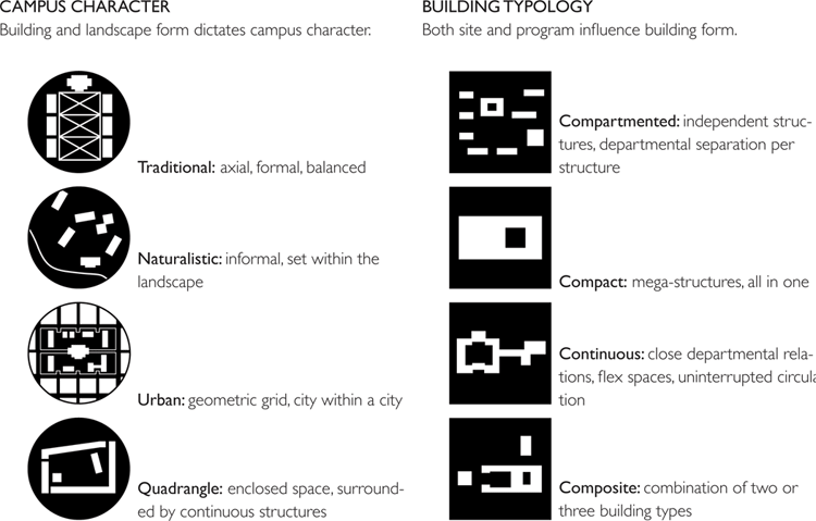
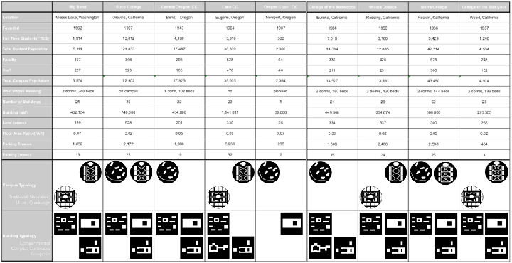
The Urban Design Lab agrees that Brubaker’s three form generators – the unique nature of site, education program and age – influence each and every campus. By comparing research in this chapter with existing literature on the planning and design of junior and community colleges from the 1960’s, the UDL has composed a series of icons based on campus characteristics and building typologies highlighted by Brubaker.
To better understand the design needs for the community college of the 21st century, existing community colleges, and physical characteristics of regional schools needed to be identified and compared. A modified comparative analysis method employed by Michael Southworth (1995), in his study Walkable Suburbs, and Ayers Saint Gross Architects (ASG), in their study titled Comparing Campuses (1998-2000) will be particularly appropriate. The analysis describes and evaluates the colleges by combining ASG and Southworth’s comparative models looking at:
- Built form - showing the footprints of all
campus structures and adjacent developments;
including roads, parking lots/spaces and pedestrian pathways through figure-ground graphics. - Access - showing distance and accessibility
throughout campus shown through figureground
graphics. - Layout and character – expressing the quality and character of the campus.
In addition to studying the form, circulation, access and character, the analysis compares each community colleges’ facts and figures to compare the proportions or scale of community college campuses:
- Campus Population: full time equivalency students
(FTES), total student population, number
of faculty and staff, total campus population;
- Campus Housing facts: number of dorms and
bed count;
- Campus Land Use: number of buildings, gross
square footage, acreage of land holdings, floor
area ratio, number of parking spaces, and acres
of parking.
I will also attempt to link Brubaker’s campus characteristic and building typologies from the previous section by assigning one or more icon from both the campus characteristics and building typologies to each campus.
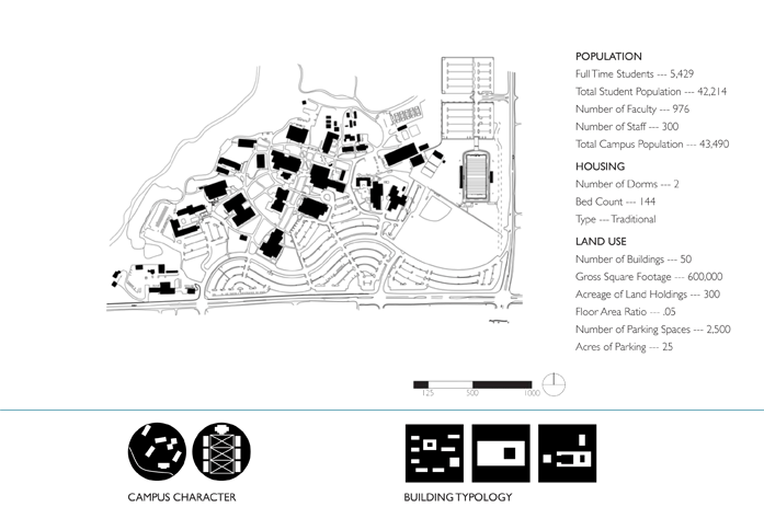
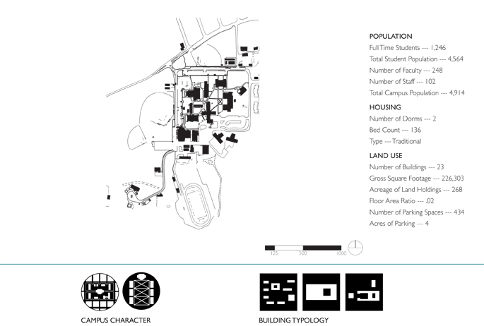
Community college selection. Selection of each community college was based on characteristics that best met the ideal conditions discussed with the local community college, LCC’s, representative(s). The selection process was carried out by an internet search to compile a complete list of regional community colleges in Oregon, Washington and Northern California. An examination of each schools’ website excluded schools that did not have a housing component on or in association with their campus. To complete the initial selection process, a review of aerial photos was used to assess the school’s land-use pattern, proximity to the urban fringe and closeness to a major highway. In the fall of 2009, twenty University of Oregon architecture, landscape architecture, and planning students made visits to thirteen community colleges. The students produced precedent studies that have helped inform the analysisof each school. The sites were studied to glean lessons learned from them that can contribute to the creation of a framework for the planning and design standards for the 21st century community college. In the spring of 2010, the Urban Design Lab commenced a secondary examination of the thirteen community colleges to gather the data we would need for the comparative mapping process. Four of the schools were excluded from the final selection process due to a lack of data, leaving nine case study sites to compare, which included Lane Community College for comparative purposes of each school. The sites were studied to glean lessons learned from them that can contribute to the creation of a framework for the planning and design standards for the 21st century community college.
In the spring of 2010, the Urban Design Lab commenced a secondary examination of the thirteen community colleges to gather the data we would need for the comparative mapping process. Four of the schools were excluded from the final selection process due to a lack of data, leaving nine case study sites to compare, which included Lane Community College for comparative purposes (see figure 3-7).
Figure 3-7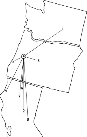
Map Key
1. Big Bend Community College
2. Butte College
3. Central Oregon Community College
4. Lane Community College
5. Oregon Coast Community College
6. College of the Redwoods
7. Shasta College
8. Sierra College
9. College of the Siskiyous
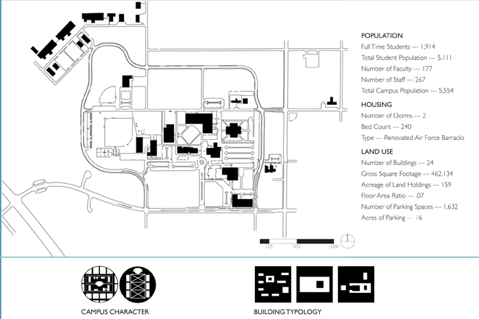
BIG BEND COMMUNITY COLLEGE
Moses Lake, Washington Founded: 1962
LAYOUT AND CHARACTER
Big Bend Community College (BBCC) acquired the 159-acre former Larson Air Force Base in 1966, and in 1975, it became the permanent college campus for all programs. Grant County International Airport is located to the north of the school. To the northwest, the land is undeveloped, non-irrigated open space. And to the south lays the city of Lake Moses. BBCC is situated two blocks north of the Moses Lake’s nearest residential neighborhood and directly east of Coulee Corridor, otherwise known as Route 17. The remaining land surrounding the college is predominantly agricultural.
The prior use has significantly defined its physical layout and character of the
school. The distance between buildings discourages students and employees
from walking, particularly in the winter months. Big Bend’s vehicular entrances
are in-line with the city grid and lead to parking lots that front most buildings.
The campus is surrounded by a ring road, enforcing the dominance of the
automobile on campus and disrupting the urban grid. BBCC continues to use
many of the old hangars and barracks from the base. Todd Davis, head of maintenance
and operations explains the campus motto regarding retrofitting old
building when he said, “that there is no permanent wall.” This maxim helps explain
why the hangar buildings are used for automotive, aeronautics and welding
courses, and the barracks are used for dormitories.
Even with the reuse maxim, many buildings are prohibitively expensive to renovate. This has led to new construction in the core of the campus. The construction has begun to centralize facilities, enhancing accessibility and concurrently updating the look and feel of the campus creating a more welcoming aesthetic.
BUTTE COLLEGE
Oroville, California Founded: 1967
LAYOUT AND CHARACTER
The campus is located on a 928-acre wildlife refuge located fifteen miles southeast
of Chico, California and is four miles east of Highway 99. Nestled within
the Sierra Nevada foothills, the campus has a large change in elevation and
provides interesting views in and out of campus. Many of the buildings are built
into hillsides helping to break up large open spaces into intimate, human-scaled
areas. In a location where temperatures exceed 100 degrees; shaded indoor
and outdoor spaces are necessary.
Due to budget cuts in the late 1970’s, only partial construction of the campus
was completed. Butte College has met their 250% increase in enrollment with
the use of temporary portable facilities; some of these trailers have been in
uses for almost 40 years. In 2001, the Butte College community created educational
and facilities master plans. The plans helped facilitate the award of an $85
million dollar bond measure and subsequent renovation of the Library (2007),
the demolition of trailers as construction progressed and new buildings such
as: the Public Health Center (2001); the Learning Resource Center (2004); the
Arts Center (2008/$28.7m); and the Student & Administrative Services Building
(2010/$22.3m).
As members of the American College & University President’s Climate Commitment,
Butte College has agreed to follow specific actions leading towards
greater environmental sustainability. This is partly accomplished with over
10,000 PV generating almost 2 megawatts of DC electricity, on-site water treatment
and energy plant. Butte has the largest community college transportation
system in California, moving over 1,700 students a day. Despite the rural surroundings
and with the help of new construction, the campus core feels quite
dense and almost urban. The abundance of outdoor gathering spaces and wide
sidewalks allows circulation to be unimpeded while groups congregate.
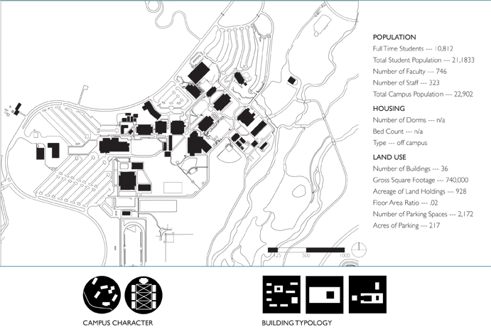
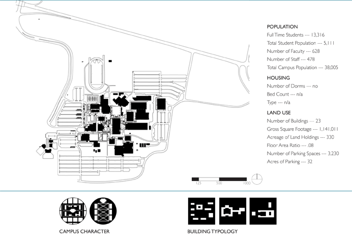
CENTRAL OREGON COMMUNITY COLLEGE
Bend, Oregon Founded: 1949
LAYOUT AND CHARACTER
Central Oregon Community College (COCC), voted most beautiful campus by Newsweek in 1960, lies in the high desert of Bend, Oregon. COCC is surrounded by single-family homes on all sides and is bisected by its main access road, NW College Way. Initial planning for the campus focused buildings near the summit of Aubrey Butte, where the slope is the fairly steep. This allowed COCC to take advantage of the magnificent views, but also created accessibility issues the school has been coping with ever since.
The upper campus - the steeper of the two – has more accessibility and wayfinding issues than the lower campus, creating greater dependency on the automobile and auto related issues like parking and carbon monoxide emissions. Although many of the lots are smaller, they disrupt pathways, obstruct views and disburse outdoor social spaces. The sprawling organization of the upper campus diminishes the sense of a unified campus.
The lower campus, on the other hand, is flatter and offers COCC opportunities to address some of these issues. Recent planning efforts on the lower campus include a pedestrian thoroughfare along NW College Way that could create a better pedestrian experience; and a new campus center building that ha created gathering and social space previously lacking, while focusing on a friendlier centralized campus core.
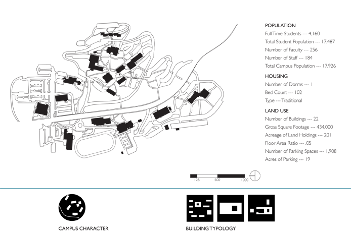
LANE COMMUNITY COLLEGE
Eugene, Oregon Founded: 1964
LAYOUT AND CHARACTER
Nestled in the south hills of Eugene, Oregon, Lane Community College (LCC)
is home to over 36,000 students. LCC sits in the Russell Creek Basin and is
surrounded by a mixed diciduous forest to the south and west. To the north
lies a vast wetlands with 30th Avenues bisecting. Interstate - 5 (I-5) runs north
south to the east with two parcels of land separating it from the main campus.
Just beyond the wetlands are large lot single family homes, some commercial
and light industrial business. LCC exists today much as it did when it was first
constructed with several new buildings surrounded by a vast sea of parking.
LCC is located less than one quarter mile from I-5 and has two entrances, two of them located d irectly off 30th Avenue. The westerly most entrance has a serpentine boulevard that directs facutly, staff, students and visitors directly to one of many parking lots and the secondary 30th Avenue entrance is closer to I-5. A potential third entrance, although on maps was never realized and would split off from Eastway Drive at the intersection of Eldon Schafer Road, which could runs perpendicular to I-5 and connect with McVay Highway.
The college is built into a slope and therefore quite terraced. The design of the campus attempts to ameliorate this site constraint by tiering the campus into the hillside. The buildings were constructed in the Brutalist style of architecture, in French, beton brut, literally meaning raw concrete. Lane Community College is challenging to navigate and although set within a beautiful setting, is not aesthetically pleasing.
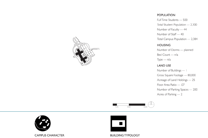
OREGON COAST COMMUNITY COLLEGE
Newport, Oregon Founded: 1987, New Campus 2009
LAYOUT AND CHARACTER
Oregon Coast Community College (OCCC) has a brand new campus located
in the coastal town of Newport, Oregon. It is nestled in the woods above the
Yaquina River and surrounded by lush coastal forest. A bond measure passed in
May 2004 funded the facilities. Prior to the transition to the permanent campus,
OCCC leased facilities in town.
Currently, there is a single building that has been in operation since October
2009. The new building was constructed larger than the current services
require, ensuring future growth. There is one entrance to the OCCC campus
with one large parking lot capable of holding 200 vehicles.
OCCC is located next to Wilder, a mixed-use development that is under construction.
The college and Wilder are developing simultaneously and with each
other in mind. To create a more cohesive, livable environment the two entities
have partnered to create a node of shops and conveniences that both the
college community and the residents’ of Wilder can enjoy. An Aquarium Science
building, in the construction documentation stage of design, is the next building
in the works at OCCC.
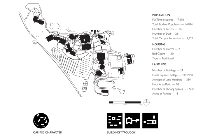
COLLEGE OF THE REDWOODS
Eureka, California Founded: 1964
LAYOUT AND CHARACTER
The campus is located on a 334-acre site, approximately seven miles from the
city of Eureka. Nestled below the redwood forest, the campus has expansive
views to the water. College of the Redwoods has been developed over time
and creates a cohesively designed environment.
A modern Learning Resource Center, constructed in 2002, fits well aesthetically with the older facilities and surrounding campus. The rolling topography of the existing campus, along with the spread-out facilities, creates a campus that is somewhat difficult to navigate.
There are three entrances to the Eureka campus, all from Tompkins Hill Road. The majority of parking is located on the south side of the campus with some smaller lots on the north side. A new entry drive and pedestrian drop-off was developed in 2009, which improved access to the campus and to the proposed new Student Services/Administration/Theatre building.
SHASTA COLLEGE
Redding, California Founded: 1950
LAYOUT AND CHARACTER
Shasta College (SC) is located approximately two miles from the city of Redding.
The Shasta College campus was originally a fur and trading center of
the Wintu Indians, later owned by a soldier and his family after the Mexican-
American War. Shasta College grew so rapidly that, in 1964, voters approved a
bond issue for construction of a 337-acre campus at the current main campus
location.
The college is relatively flat. The southern edge abuts Highway 299 and is approximately
three miles from Interstate 5. The area surrounding SC is predominantly
large lot, single-family neighborhoods.
There are two entrances onto the campus, both from Old Oregon Trail leading
to three large parking areas located on the north, east and south sides of
the campus, with some smaller lots throughout. The campus is spread out with
accessible pathways that weave from building to building. In 2005, a $1.5 million
Early Childhood Educational childcare center and instructional facility opened.
Their latest project also includes a new Health Sciences and University Center
Building completed in the fall of 2007. Despite the vast timeframe that the
campus had been developed, the overall campus fits seamlessly.

SIERRA COLLEGE
Rocklin, California Founded: 1936 (Placer Junior College)
LAYOUT AND CHARACTER
Sierra College is a rural campus located near the foothills of the Sierra Nevada
Mountains at the edge of suburban Rocklin, California. The campus is approximately
twenty miles from the State Capitol along Interstate 80. Sierra’s origins
date back to the beginning of junior colleges in California. Founded in 1914,
Placer Junior College was Sierra’s forerunner.
The campus is bound on three sides by Sierra College Blvd to the east, Rocklin
Road to the south, and Interstate 80 running diagonally from the southwest to
the northeast. The surrounding land to the south is predominantly suburban
neighborhoods; to the east, open scrub brush; and to the west, strip mall development
along I-80 and a mix of light industrial and residential.
Sierra College has three main entries leading to three large parking lots and
several small parking lots scattered throughout campus. A large unpaved, gravel
parking area sits across Rocklin Road. The campus is developed on a gently
sloping hillside with 70 acres of nature trails to the north. The pathways are
very accessible leading to a variety of open spaces and buildings. Several new
buildings have been added recently.
COLLEGE OF THE SISKIYOUS
Weed, California Founded: 1957
LAYOUT AND CHARACTER
College of the Siskiyous (CS) is a small campus on relatively level ground for
the area. The campus is located on the southwest side of Interstate 5, opposite
of the nearest town, Weed. To the south and east of the campus lie several
buttes, while a mix of single-family homes and multifamily apartments lie to the
east and north side of campus.
The campus has two main entrances to the north and east. The campus core is planted with grass between the buildings with appropriate pedestrian pathways. Parking surrounds the campus with recreation fields beyond. Though the campus seems quiet and low key it is actually quite attentive in its attempts to work with the newest ideas of working towards a sustainable future. The facilities directors are acting as leading stewards to drive the college in this direction.
There are multiple opportunities for enjoying the great outdoors in this lush region. Just beyond the edge of the housing there is natural forest and wildlife areas with nature trails.
Studying community college form has
helped the Urban Design Lab understand
how these educational villages
have formed. Many of the case studies
were designed and developed in the
1960s. Each campus has its own unique
setting - high desert, lush forest, or old
military base - but each share the designation
of being located at the fringe of
a city in the county they serve.
All of the campuses have a predominant
campus characteristic and most
have a secondary. An example is Big
Bend Community College. It sits at the
edge of town, yet the streets and buildings
fit into the urban grid. The newer
section of campus starts to create a
more traditional campus setting; linking
buildings with walkways - creating
a city, within the city. Every campus,
except Oregon Coast Community
College has the same building typology:
compartmented and one other, developing
towards a composite as growth
and expansion occur.
The ratio of people to parking spaces ranged from 3.4:1 to 17.4:1 with a mean of 10.1. LCC fall just above the average with 11.7:1 All the school have low Floor Area Ratios; LCC the highest.
Lane Community College - Campus Long Range Planning |
